| BEAUTEMPS-BEAUPRÉ, Charles François, hydrographer and cartographer (Neuville-au-Port, Marne, 6. VIII. 1766 - Paris, 16. III. 1854). He became a hydrographic engineer of the Hydrographic Institute of Paris Navy in 1785. He noticed that the rules by which charts were made were incorrect, because they were drawn according to information from ships' logs and maritime directions and observations. In order to perfect the map making method, he went aboard a ship named La Recherche which was searching for La Pérouse's missing expedition in the west Pacific. On that journey, he was using astronomic and geodetic observations for determination of certain positions, he was determining point coordinates using a new arithmetic method and he was performing geophysical measurements. From 1799 to 1805 he was surveying the mouth of the Rhine river concerning Napoleon's intention of building a war harbour at that location. By Napoleon's order in 1806, as a replacement director of Navy's Hydrographic Institute, and with the help of the ship lieutenant (lieutenant de vaisseau) Titian, he performed hydrographic survey of coasts and harbours of the Adriatic Sea. The result of the measurements was the renowned manuscript of the sea atlas Reconnaissance hydrographique des ports du Royaume d'Italie... (Hydrographic presentation of harbours of Italian Kingdom). Italian cartographers Birasco and Ekerlin from Deposito generale della guerra designed the Atlas under the leadership of the Italian minister of war, general Caffarelli. Some call the Atlas Beautemps-Beaupré's atlas of the eastern coast of the Adriatic Sea, because it was made on the basis of hydrographic survey's information which was carried out in the Adriatic by French hydrographers in the spring and summer of 1806 under hydrographer Beautemps-Beaupré's command; some call Napoleon's atlas of the eastern coast of the Adriatic because there are serious indications that it was made specially for Napoleon. Accompanying the Atlas is Beautemps-Beaupré's report which was written in Paris in July of 1807, and has 65 pages of calligraphically written text, acts as a supplement to the Atlas and with it serves as an unseparable entirety. Defects of earlier charts are listed in the introductory part of the report, after that there is a description of situation in the Adriatic of that time, and then there is a thorough description of every harbour featured in the Atlas. It was signed personally by Beautemps-Beaupré and minister Caffarelli. The Atlas, together with the original report, was bought by the National and University Library in Zagreb in 1979. The Atlas contains 17 pages, 15 of which are plans and charts, and 2 pages of landscape, from Piran to Split. The plans, the charts, and the views of landscape are originals, hand drawn with ink and watercolour on handmade watercolour paper. After a performed hydrographic survey in the Adriatic in 1806 under the leadership of Beautemps-Beaupré, besides the aforementioned Atlas, in 1807 a map of Dalmatia, which was kept by Napoleon, was made. While making that map surveyors were using existing maps, so that the maps were first reduced to a same scale, 1:100 000, and were then supplemented with astronomic information and observations for towns of Zadar, Split and Dubrovnik. It is known as Napoleon's map of Dalmatia. The map was destroyed in 1812, but the War Office in France possessed old sketches and drawings of maps by which a second map of Dalmatia, which was similar to the first, was drawn. The map is held in Archives des cartes Ministere de la guerre, Dépôt de la guerre. It was made of 13 pages. When he returned to France, Beautemps-Beaupré carried out a survey of the coast between the Rhine and Elbe rivers, and from 1816 to 1838 a survey of the French coast. In 1848, when he was 82, he retired. Through 63 years of his prolific work he founded the principles of precise hydrography and brought up generations of engineers, that is the reason the French and the English named him "the father of hydrography". He was the first to apply the geometric rules of perspective in practice. Besides atlases he published collections of several hundred charts named Pilote Française and Nouveau Neptune. He was a member of the French Academy of Sciences.
|
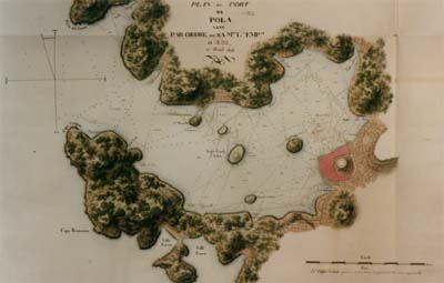
The plan of Pula's harbour from Beautemps-Beaupré's Atlas of the eastern coast of the Adriatic which is kept in the National and University Library in Zagreb
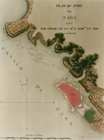
The plan of Zadar's harbour from Beautemps-Beaupré's Atlas of the eastern coast of the Adriatic which is kept in the National and University Library in Zagreb |