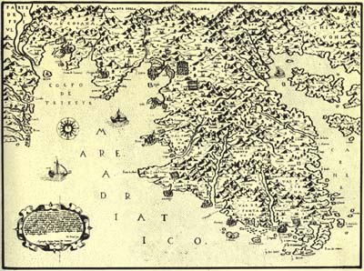
Map of Istria from 1569 by Giovanni Francesco Camocio
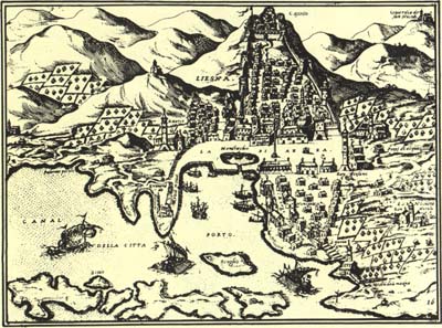
View of Makarska from 1572 by Giovanni Francesco Camocio
| CAMOCIO, Giovanni Francesco (Camocius, Camotius, Camotio; Giovani, Gioan), cartographer, publisher and map dealer. As a bookseller and publisher, Camocio was granted privileges by Venice in 1522. Apart from a bookshop situated on S. Lio in Venice with a sign al segno della pyramida he owned an engraving (cartographic) workshop where numerous maps and views, sold as separate sheets, were made. As a publisher he used to sign his works with apresso or apud G. F. Camocio cum privilegio. Camocio had a particular interest in Croatia, the area of which, apart from the information obtained from topographers and providers of cartographic data, he had a first hand, personal knowledge. From 1560 to 1579 he issued a large number of maps, some of them containing representations of Croatian lands. In 1563 he issued the map Novo dissegno della Dalmatia et Crovatia MDLXIII. In Venetia apresso Gioan Francesco Camocium al segno della Pyramide in Venice, one of the first published regional maps of Croatia. The map presents the part of the Croatian coast to Sibenik with the hinterland. He is the author of the map of Istria published in 1569 in Venice. The isolario titled Isole famose, porti, fortezze e terre maritimme sottoposte alla ser. Sig. di Venetia, ad altri Principi Christiani, et al Sig. Turco nouamete poste in luce. In Venetia alla libraria del segno di S. Marco was published in his workshop in 1572. The isolario containing maps and views of the Adriatic, Ionian and Aegean coast is kept in the museums and libraries in Zagreb, Split, Venice, Trevisi, Rome, Milan, London , Vienna and in a considerable number of public and private collections. In the Croatian State Archives in Zagreb there is an integral copy of the isolario which contains 88 sheets marked with numbers. The National and University Library in Zagreb has in its possession an edition of the isolario containing 78 unnumerated sheets with slight differences in the content and sequence of the maps. Sixteen maps or views in this isolario presenting the Croatian coast are the maps of the Adriatic sea, Istria, views of Pula and Osor, maps of Zadar with the surrounding area, of ©ibenik with the surrounding area, views of Sibenik and Skradin, then panoramic maps of Trogir with the surrounding area, of Split with the surrounding area, a cartographic-panoramic representation of Makarska with the surrounding area, a panoramic map of the area of Klis and Solin, a view of the town of Hvar, maps of the islands of Hvar and Korèula, a map of Dubrovnik-Boka Kotorska waters. Eleven sheets in this isolario, published in 1570 and 1571, bear the name of Giovanni Francesco Camocio as a publisher and are signed by apresso Gio. Franc. Camocio cum privilegio, while one sheet bears the mark of his bookshop alla libraria dela pyramide. However, the title page of the isolario bears neither a year of publication nor a name of the publisher, but contains the initials NB which are known as initials of Natale Bonifacio. Neverthelles, recent research has established that Bonifacio is not the author of any single sheet in this isolario, though it may be concluded from the fact that made and signed the title page. | Map of Istria from 1569 by Giovanni Francesco Camocio View of Makarska from 1572 by Giovanni Francesco Camocio |