| CORONELLI, Vincenzo Maria (Corneille, Marc Vicent; Marco, Vicenzo), theologian, cosmographer, geographer, cartographer and publisher (Venice (Ravenna), 16. VIII. 1650 - Venice, 9. XII. 1718). He studied astronomy from 1667 to 1671; his teacher was Pietro Martire Rusca. In 1671 he joined the Franciscans and as a monk he lived in a monastery S. Marie Gloriose dei Frari in Venice. He studied theology and humanities in the Roman Collegium S. Bonaventura, where he also studied Euclid's geometry. He received his PhD in Rome in 1673. During his stay in Padova, from 1674 to 1677, he was researching Euclid's geometry together with count Francesco Damiani. He was occupied with geography, history, cartography, copper engraving, globe making, and building. On duke Rannucio Farnese's request, in 1678 he made a large pair of handmade globes. In 1680 he made two globes, one of the sky and one of the Earth. With a journalist's instinct he followed Venice's war campaigns of conquering properties in the Adriatic in 1680's as a possibility for the first big publishing swing. From 1681 to the December of 1683 he lived in Paris, and then he returned to Venice to the monastery which was his home until he died in 1718. In the monastery he organized a cartographic workshop in which he made and revealed his works. During the period from 1683 to 1704 he made a couple of globes of the Earth and of the sky. He made two large globes for Louis XIV, each with a radius of four metres. The globes left a strong impression but they also caused violent reactions, which resulted with their destruction. In 1685, Coronelli became Hungary's Provintial; in 1701 he became a general of his order. As a reward for his prolific cartographic activity, the Senate in Venice promoted him in 1685 into a cosmographer of the Republic of Venice with earnings of 400 florins and a privilege of copyright for 25 years. He was very famous in Venice and he had access to the secret archives of the Republic of Venice which he could use to gain information he needed to make his maps. He collaborated with the most famous geographers and publishers of his time. He travelled to London, the Netherlands, Germany, Austria, Hungary and Constantinopolis. During the 17th century, Senj was a frequent object of surveying work of Austrian and Venetian cartographers. Besides Stier, Weiss, Pieroni and Valvasor, the town's survey was also carried out by Coronelli. He was famous not only for his many monumental globes, but also for a large number of maps which were made as a result of widely established, systematic information gathering. About 400-500 of his cartographic works is known. It is assumed that Coronelli drew his maps alone on a copper plate. He used his copper plates multiple times for different publications. In 1685 (1686) he published two works about Moreia: Conquiste della Republica in Dalmazia Epiro e Morea and Memorie istoriografiche del Regno di Morea e di Negroponte. That collection of plans and panoramic views was so successful that a large number of revised editions and translations to a number of languages was published. He also made maps for Pietro Valieri, who was a general deputy (proveditore) in Dalmatia. In the summer of 1686 he returned to Paris to gather information for his atlas Atlante Veneto. His smaller isolario of the Adriatic and Ionian coast titled: Mari, Golfi, Isole, Spiaggie, Porti, Citta, Fortezze ed altri Louoghi dell' Istria, Quarner, Dalmazia, Albania, Epiro e Livadia published in Venice in 1688 is also important. The isolario has quite a few pages with maps or panoramic views of Croatian coast or seaside towns. A copy can be found in the National and University Library in Zagreb. Residents of Dubrovnik decided to award him with 20 gold coins in 1685, even before he published his work, if he publishes a text and information about the Republic of Dubrovnik in it. In a special letter they asked him to publish the exact same information and that their report be printed in his book without any changes. They accompanied the letter with a geographic map of the Republic of Dubrovnik. Coronelli added the information he received, so it is the first conserved geographic map on which the area of the Republic of Dubrovnik is quite precisely shown. The map was published in the aforementioned edition, but also in his other works titled Stato di Ragusi, Bocca del Fiume Narenta, Isole di Lesina e Curzola nella Dalmatia posseduta Dalla Serenissima Republica di Venetia. Coronelli also added a graphic presentation of the caravan route from Dubrovnik to Constantinopolis Viaggio da Ragusi a Costantionopoli per la Bosna, Servia, e Romania. The isolario contains a map of Zadar's wider surroundings Contando di Zara, Parte della Dalmatia. Considering its size and scale, we can say that it is a very detailed map, and can be considered the first topographic map of that area. The maps of Boka kotorska Disegno topografico del Canale di Cataro and the map of Neretva's mouth Corso del Fiume Narenta Dalla Citta di Ciclut fino al mare acquistata, Con altri Luoghi Dall Armi Venete were also published in the isolario. The map of Neretva shows old branches of Neretva's delta and nearby large swamps around Opuzen and Metkovic. It is the first detailed map of that part of the Adriatic coast. Besides the already mentioned maps, Coronelli also published quite a few panoramic views of Croatian seaside towns and forts. A total of 68 presentations can be found in the isolario of the Adriatic-Ionian coast. The peninsula of Istria and the islands of Kvarner are best shown on his map Distretto della Dalmazia Diuisa ne suoi Contadi o. 1:500 000 with two pages from 1688. In 1689 he became a lector for geography. He ambitiously conceived and carried out the encyclopaedic work Biblioteca Universale in 13 large volumes published from 1690 to 1701, the first five of which mostly contain geographic maps, and the rest contain town, harbour and fort plans and maps, and besides the texts, panoramic views of more important towns, all sorts of historical and ethnographic, sea and war scenes, but also portraits of noble, royal and religious people and important persons. Besides lots of compilations and uncritical use of maps of others, he also compiled original maps on the basis of newly gathered information. The area of Croatia and Croatian coast of the Adriatic are shown on many of his maps which were later taken by a lot of European publishers. His largest cartographic work is Atlante Veneto, an atlas whose first volume was published in 1691, and the second one in 1695. A copy of the atlas can be found in the University Library in Ljubljana. The second part of the volume was published in 1696 titled Isolario dell'Atlante Veneto in which are a few maps of the area of Croatia. A copy is available at the National and University Library in Zagreb. His large map of the countries of the Danube Basin Corso del Danubio da Vienna Sin' a Nicopoli e paesi Adiacenti is in the first volume, Atlante Veneto. It encompasses six atlas pages and can be, if needed, transformed into a special map. The map shows almost all Croatian countries in quite a large scale. In Isolario dell'Atlante Veneto atlas there is a map Ristretto della Dalmazia, Diuisa né suoi Contandi, gia presentata alla Serenissima Republica di Venezia. The map shows the Adriatic coast from Istria to the mouth of the Bojana. It consists of two atlas pages, which have a size of 120×44 cm when put together. Because of its format and large scale, it shows almost everything that the residents of Venice knew about the Adriatic coast, seaside towns, islands, rivers and the relief in that time. Coronelli was also active as a cartographer or an illustrator of the editions in which Venetian victories against the Turkish were glorified. His maps and plans which show Croatian landscape can also be found in those publications. His geographic-historical work can be found in the Metropolitana Library in Zagreb in the German edition Historische und topographische beschreibung der Reiche Morea und Negroponte; while the map of Dalmatia, published in Paris about 1695, is kept in the collection of maps of the Croatian History Museum. For all of Coronelli's contribution in knowing Croatian countries, it can be said that he was focused primarily on the Croatian coastal area. He founded the first geographic society Accademia Cosmographica degli Argonauti in Venice in 1680 (1684, 1693), which is one of the oldest geographic societies in the world. He wanted the society to become a publishing society which would organize the distribution of his works all over Europe.
|
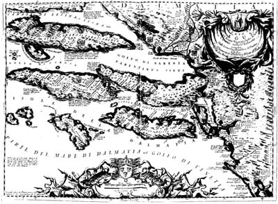
Coronelli's map "Stato di Ragusa", which was made as a copper engraving and published in Paris by J. B. Nolin. It was published in Coronelli's work Mari, Golfi
in Venice in 1706 and in his other works
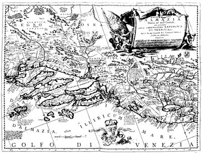
A map of Dalmatia from Coronelli's Isolaria, Parte 1, Venice, 1696. |