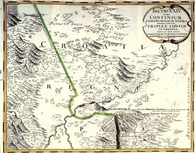
Topographic map of the Turkish-Croatian border by Johann Müller
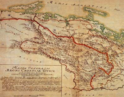
Part of the map of Croatia by Johann Müller
| MÜLLER, Johann Christoph, (March 15, 1673, Nürnberg - June 21, 1721, Vienna), military engineer, topographer, cartographer. Having studied humanities, Müller was coached by the astronomer and copperplate engraver G. C. Eimmart in mathematics and drawing skills. In 1696, as an officer of Engineer Corps (Genie-Offizier) he entered the service of lieutenant Luigi Ferdinand count Marsigli and carried out astronomical observations in Vienna. Within surveying work for Marsigli's Danubius Pannonico-Mysicus he had a practice in field surveying and enhanced his knowledge. After Karlovci Peace Treaty, count Marsigli appointed him a commissioner for demarcation (Grenzscheidungskommissär) and charged him with a duty to collect data for an accurate map of Hungarian lands. He was also charged with a leading position in surveying and cartographic activities carried out on the ground. Müller carried out surveying of settlements, of the courses of rivers and streams, roads, swamps, forests and relief. The sketches of smaller towns were presented in perspective, while the survey of military fortifications was carried out in ground plan. Müller's basic map of the border lines established after Karlovci Peace Treaty consists of 24 sections made at a scale of 1:37 500. The original is kept in the Cartographic Collection of the National Library in Vienna, and a complete copy in War Archives in Vienna. The map does not possess a single title; its sections, which lean against one another , are not of the same size. To Marsigli's demand Müller made several general maps of the newly established border at a more adequate scale and they are stored in the War Archives in Vienna. Apart from complete presentations of the newly established border Müller drew general maps of particular, larger and smaller, border sectors and a number of them is kept in the War Archives in Vienna. Among other maps drawn by Müller topographic sketches drawn by pen in sepia are to be mentioned. After the commission for demarcation appointed by Marsigli finished its work Müller was not engaged in cartography for several years. In 1707 his interest in the Croatian lands revived. He was given a task to make a large size general map of Hungary with Croatia, Slavonia and Transylvania at a scale of 1:550 000. The map, finished in 1709, is considered to be a masterpiece of Baroque cartography and is stored in the War Archives in Vienna and the National and University Library in Zagreb. Müller included in the map all data concerning Croatia and Slavonia obtained in 1699 and supplemented them with more recent ones. In the course of preparations for the map making, Müller spent about two years doing ground surveys. From 1708 to 1712 he carried out surveys of Moravia by counties and in 1720 published a map of Moravia, cooper engraved, on four sheets at a scale of 1:180 000. Schweizerisher Atlas was published in 1712. In the same year he began work on a survey of Bohemia which was finished in 1720. An engraved map of Bohemia (Mappa geographica Regni Bohemia) was published in 1722 and it contained 25 sheets at a scale of 1:137 500. Having finished surveying of Bohemia, he began doing preparatory works for survey of Silesia, but was, unfortunately, stopped by death. | Topographic map of the Turkish-Croatian border by Johann Müller Part of the map of Croatia by Johann Müller |