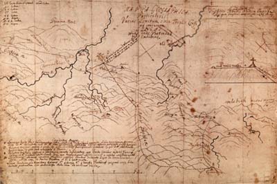
Topographic sketch of the triple-frontier area from 1699 by Pavao Ritter Vitezovic
| VITEZOVIC, Pavao Ritter (Ritter Vitezovic, Pavle; Ritter, Paulus), (January 12, 1652, Senj - January 21, 1713, Vienna), publisher, poet, polyhistor, cartographer. He attended primary school in Senj and Jesuit grammar school in Zagreb. Having finished the sixth grade of rhetorics he went to Rome where he met Ivan Luèic. Vitezovic was trained in cartography and geography in Vienna by the cartographer Georg Matheus Vischer. Then he spent two years in Vagensperg learning surveying and copperplate engraving from Johann Weikhard Valvasor. He prepared for Valvasor the majority of models for the views of Croatian towns and engraved them in copper. In 1679 he returned to Senj. In 1684 during his stay in Linz as an envoy of Senj, Vitezovic published Odijeljenje sigetsko, and translated his German surname Ritter into Croatian Vitezovic. He enjoyed taking walks in the countryside with a sketching pad where he would draw towns and towers which would be later engraved in copper. In this way he created the copperplates which were published in Valvasor's album Topographia Ductus Carnolia Modernae, and in the book Die Ehre des Herzogthums Crain. He distinguished himself in the war for liberation of Lika and Krbava, and in 1691 was appointed vice prefect of the district of Lika. From 1694 to 1709 he was head of the National Printing House and signed himself as Paulo Ritter de Segna, nobili Croata (Paul Ritter of Senj, noble Croat). His printing house issued a number of important books, textbooks, calendars, prayer-books and declarations. Among them Kronika aliti spomen vsega svijeta vikov (A Chronicle or History of the World) from 1696 deserves particular attention. In 1699 he was, as a skilful cartographer, delegated into the Austrian military commission for demarcation between Croatian lands and Turkey led by count Ferdinand Luigi Marsigli. Vitezovic made sketches of surrounding terrain in collaboration with the cartographer Johann Christopher Müller. The cartographic documentation they produced remained in manuscript and is stored in the State Archives in Vienna. Court in Vienna entrusted Vitezovic with a task of writing regular monthly reports on the progress of work on demarcation. One of these reports, finished on September 9, 1699, was accompanied with a map made by Vitezovic and, due to circumstances, did not reach Vienna. It is now stored in the Croatian State Archives in Zagreb as a unique manuscript item. Though the map does not bear a signature, comparative analysis of other manuscripts by Vitezovic leads us to believe that it is his work. His maps made in the period of Karlovci Peace Treaty (a historical map of Croatia, a map of Lika and Krbava, which may have been compiled with the help of Müller and a topographical sketch of the terrain around Tromeda and Knin) are kept in the Croatian State Archives in Zagreb. | Topographic sketch of the triple-frontier area from 1699 by Pavao Ritter Vitezovic |